Global Map
All assets with a position on one map, with marker clustering, map and satellite views, custom marker icons and a side panel to search assets and filter by asset template.
See where every tracker, vehicle, bin or sensor is right now, replay where it has been, and let Widgelix react the moment an asset enters or leaves an area you draw on the map.
Trackers report coordinates every few minutes, but a list of latitude and longitude values does not tell a dispatcher that a container left the yard or a vehicle is outside its zone. Teams end up checking maps by hand and finding out too late.
Turn on “Take position from payload” in the asset template and name the latitude and longitude fields. Fixed assets can get coordinates entered by hand.
The Global Map shows every asset with a position, clusters dense areas and opens a card with the latest values. Map widgets add route history to dashboards.
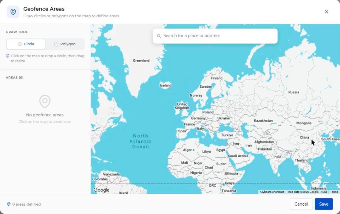
Choose Geofence as the condition, draw circles or polygons, and pick “In the areas” or “Outside the areas”. The action alerts, escalates or sends a downlink.
No separate tracking tool: location works with the same templates, dashboards and Actions as every other sensor.
All assets with a position on one map, with marker clustering, map and satellite views, custom marker icons and a side panel to search assets and filter by asset template.
Click a marker to see the latest payload values, last update time and coordinates, copy the asset ID or open the asset.
Show every geofence used by your Actions, see which actions use it and which assets are inside it right now.
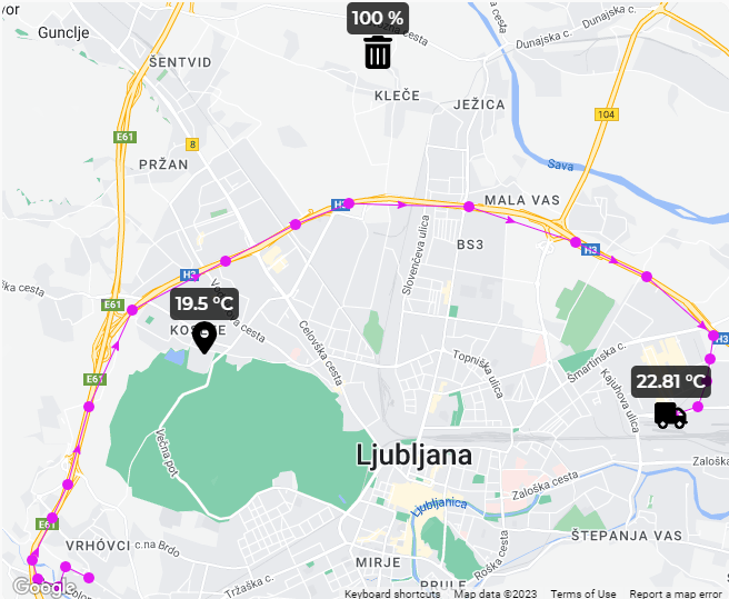
The Map widget draws the route of one asset with direction arrows; the Asset Map widget shows several assets and their paths on a site dashboard. Pick the last hour, day, week, month or a date range.
Circle or polygon areas, several per condition, with “In the areas” or “Outside the areas” comparison. Place search helps you find the site quickly.
Combine a geofence with temporal control, for example “outside the area for 10 minutes”, and with Trigger Once so the action re-arms only after the asset returns.
When creating an action, choose “Select from map” to apply it to the assets inside an area you draw, instead of picking them from a list.
Any tracker whose decoder outputs latitude and longitude works, whichever integration brings its data in.
Map widgets connect positions into a route with direction arrows and show live values next to each asset, for example the temperature of a refrigerated truck or the fill level of a bin.
| Position source | Latitude/longitude fields from the decoder, or fixed coordinates per asset |
|---|---|
| Global Map | Clustering, map/satellite view, asset search, template filter, asset and geofence cards |
| Map widget | One asset on its asset dashboard: current position or route for a time range |
| Asset Map widget | Several assets on a site dashboard, with path colours and time range |
| Geofence shapes | Circle and polygon, several areas per condition |
| Comparison | In the areas, Outside the areas |
| Timing | Temporal control (persist duration), Trigger Once, schedules |
| Responses | Email, SMS, Slack, Discord, SIGNL4, Webhook, Downlink, escalation chain |
“If a container tracker stays outside the depot area for 10 minutes outside working hours, alert the security team by SMS and escalate to the site manager.”
Any GPS tracker whose payload contains latitude and longitude, over LoRaWAN, Sigfox or another supported integration. In the asset template you name the fields that hold the coordinates.
In an Action, choose Geofence as the comparison type, open Select Geofence Areas and draw circles or polygons on the map. Choose whether the action fires when the asset is in or outside the areas.
Yes. The Map widget shows the route of an asset for the last hour, day, week, month or a custom date range. The Asset Map widget does the same for several assets on a site dashboard.
Add temporal control to the geofence condition, for example requiring the asset to stay outside the area for 10 minutes before the action fires.
Yes. Assets without GPS can get fixed coordinates in their settings and appear on the Global Map next to moving assets.
Tell us what you track and which areas matter. We'll show you maps, routes and geofence actions on your own trackers.